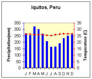
Tropical Rainforest (Af)

Lat/Long = 3.39o S, 73.18o W
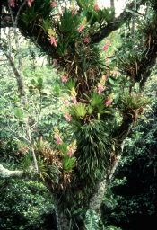
Average Annual Temperature (oC) = 26.1
Annual Temperature Range (oC) = 1.4
Total Annual Precipitation (mm) = 2879.2
Summer Precipitation (mm) =1583
Winter Precipitation (mm) = 1294.7

Map Location

bromeliad_FAO_18535.jpg (19251 bytes)

Bromelias with emerging crown
(Peru)

(Photo credit: A Brack FAO 18535)
(Used with permission)

Geographic Distribution

Britannica Online Climate Map

  • Amazon Basin,

  • Congo River Basin,

  • East coast of Central America,

  • East coast and interior of Brazil,

  • East coast of Madagascar,

  • Malaysia,

  • Indonesia,

  • Philippines.


Controlling Factors

  • High year-round insolation and precipitation of ITCZ.

  • Rising air along trade wind coasts.

  • mE air masses.

Characteristics

  • Constant high temperatures.

  • "Equal" day length.

  • Lowest annual temperature range of any climate.

  • Evenly distributed, heavy precipitation.

  • Much cloud cover and high humidity.


Back to Interactive Climate Map

Creative Commons License
This work is licensed under a Creative Commons Attribution-ShareAlike 4.0 International License..