Marine West Coast Climate (Cfb)


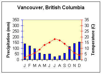
Latitude/Longitude = 49.1o N; 123.06o W
Average Annual Temperature (oC) = 9.8
Annual Temperature Range (oC) =16
Total Annual Precipitation (mm) =1048
Summer Precipitation (mm) = 277
Winter Precipitation (mm) = 771

Latitude/Longitude =51.3oN; .07o W
Average Annual Temperature (oC) = 10.4
Annual Temperature Range (oC) = 14
Total Annual Precipitation (mm) = 595
Summer Precipitation (mm) = 295
Winter Precipitation (mm) =300

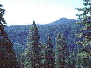
Coniferous forest of western Oregon.

(Photo credit: T. Detwyler Optilearn Inc. Photo from the World Biomes CD-ROM Used with permission)

There is a significant difference in the climate situation between Vancouver and London, both Marine West Coast climates, arises from location, local topography, and ocean current influence. The dry summer in Vancouver is due in part to subsiding, subtropical high pressure lying to the south. Precipitation is nearly double that of London due to local orographic uplift of air. Milder winter temperatures in London arise from the moderating influence of the North Atlantic Drift.

Geographic Distribution

  • Coastal Oregon, Washington, British Columbia, and southern Alaska

  • Southern Chile; interior South Africa

  • southeast Australia and New Zealand

  • northwest Europe


Controlling Factors

  • West coast location; year round influence of the Westerlies.

  • Warm ocean currents along some coasts.

  • Windward orographic influence in North America.

  • Located further inland in Europe due to east - west orientation of mountains.

Characteristics

  • Mild winters, mild summers.

  • Low annual temperature range.

  • Heavy cloud cover; high humidity.

  • Frequent cyclonic storms, with prolonged rain, drizzle and fog.

Back to Interactive Climate Map

Creative Commons License
This work is licensed under a Creative Commons Attribution-ShareAlike 4.0 International License..